 About us


")
")
")


Alberding Ntrip Caster (Networking)
Alberding Ntrip Caster is a professional and powerful GNSS data transmission software that collects real-time data streams from GNSS reference stations and transmits RTK corrections or other required data products to a large number of simultaneously logged-in users via the Internet. Unlike other Ntrip Caster applications on the market, Alberding Ntrip Caster was designed for mass deployment. The software is capable of handling hundreds of reference stations as well as thousands of user connections. Our Ntrip Caster software is suitable for local, regional and global GNSS network providers. It offers a range of advanced features to get optimal results from their GNSS infrastructure, including Grid-based networking, Nearest Base and Geofencing capabilities.
For more information on the Alberding Ntrip Caster, please refer to the datasheet.
Grid-based networking for mass usage
If virtual reference stations are to be provided for a large number of users,
the server load of the networking software and the cost of software licenses increase significantly.
A grid-based approach, which no longer directs users directly to the networking software,
but distributes them to a predefined station network using the proven mechanisms of Nearest Base procedures,
can provide a remedy. SAPOS-GeoNord, for example, provides such an extended service with the new
real-time positioning service Open Data.
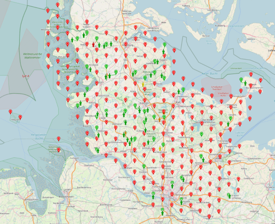
One server can provide real-time corrections to a 5-digit number of clients simultaneously. User registration
is no longer required for this free service. Costs that are independent of the number of users ensure stable financial planning.
In combination with other functions of the Alberding Ntrip Caster, even hybrid approaches are possible. For example,
areas with high access numbers can be covered by a grid and other areas by direct forwarding to the networking software.
Nearest Base procedure
Another optional component of the Alberding Ntrip Caster is the Nearest Base procedure. This automatically connects
the receiver to the nearest operational reference station, providing the user with the most useful correction
data at all times. Atmospheric residual errors can be significantly reduced and automatic switching also improves
system reliability.
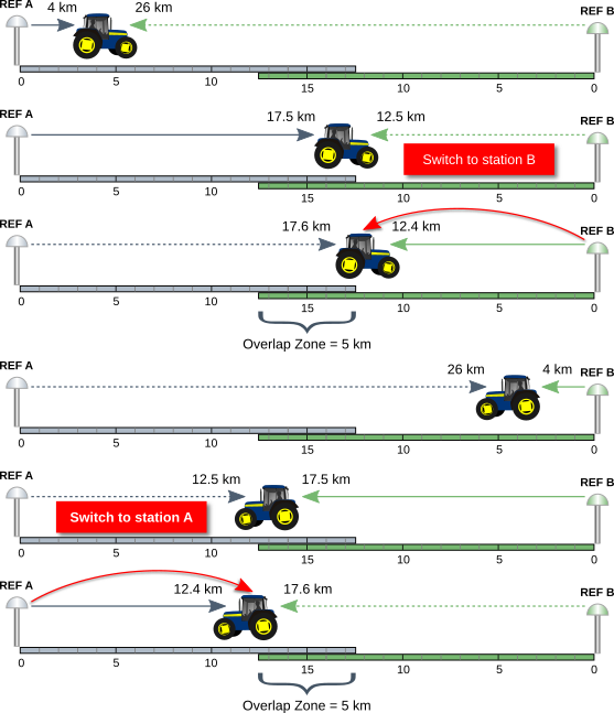
If the user moves from station A towards station B an "auto-switch" mountpoint connects the user first
to station A and then switches to station B. This automatic switching is particularly suitable for kinematic applications,
such as "precise farming".
The Alberding Ntrip Caster also allows service operators to set up so-called "overlap zones" between stations.
This avoids frequent and unnecessary station switches when working between two stations. If an overlap zone is defined
the user receiver will stay connected to station A even if the centerline between station A and B has been crossed.
Once the mutual edge of the overlap zone is reached, the user receives the data from station B. Similarly, on his way back,
the user remains connected to station B until he has passed the overlap zone and can switch to station A again.
All information on the Nearest Base procedure can be found in the data sheet.
Geofencing
Another option of the Alberding Ntrip Caster is Geofencing. Geofencing allows system operators to control user access
to data streams based on geographic location. Individual users, entire groups or different mount points can be assigned
one or more geofence zones. These virtual boundaries are defined with millimeter precision by a circle or a polygon.
In this way, the geofencing function of the Alberding Ntrip Caster can be used to define precise areas in which vehicles
or machines are allowed to move actively. This opens up a wide range of applications in the construction, agricultural
or forestry industries, for example in monitoring vehicle fleets or coordinating in-plant vehicles or machines.
In particular, SAPOS customers who need to access correction data at state borders benefit from the Geofencing function
of the Alberding Ntrip Caster. The Caster automatically switches the data stream of the respective state without the user
having to intervene.