About us


08/09/2023
Research project SSRoverDAB+ successfully completed
Area-wide high-precision GNSS position data even in regions with patchy mobile radio coverage? The
software and system solutions successfully developed and tested in the SSRoverDAB+ research project for the transmission of precise GNSS
correction data via digital radio DAB+ make it possible! On 29 June 2023, the project consortium consisting of Alberding GmbH (consortium leader),
Geo++ GmbH, inPosition gmbh and the Fraunhofer Institute for Integrated Circuits IIS presented the project results in a video conference. More than
60 interested parties followed the online presentation and the subsequent interactive Q&A session. The project was funded by the European Space Agency's
Navigation Innovation and Support Programme (ESA NAVISP Element 2).
Current market situation
Modern digitisation and automation applications in agriculture and other fields require a precise spatial reference in real time.
Satellite-based positioning (GNSS) can meet these requirements with the help of GNSS real-time correction data for the majority of
the outdoor area. Precise correction data is provided, among others, by the satellite positioning service SAPOS® of the state surveying
authorities as an open data service via mobile internet. The bidirectional VRS method and the RTCM - data format used by SAPOS® are supported
by the mobile GNSS receivers available on the market.
Due to poor mobile phone coverage in rural areas, many customers cannot use the SAPOS® service provided by the administration and have to rely on commercial
services from globally operating companies. An additional transmission of GNSS correction data via terrestrial data channels, such as digital broadcasting DAB+,
could fill these coverage gaps. In contrast to the bidirectional VRS procedure used so far via mobile radio, DAB+ broadcasting requires the transition to a broadcast
able correction data format.
The new PPP-RTK method, which is based on the SSR approach, is broadcast able without loss of accuracy and allows a bandwidth
reduction for efficient transmission of the correction data via DAB+. The lack of standardisation of SSR correction data at the
highest accuracy level is a disadvantage for the market introduction of an open-data PPP-RTK service. The GNSS sensors currently
available on the market have so far exclusively used proprietary data formats.
Project results
The ESA NAVISP-EL2 project SSRoverDAB+ developed software and system solutions for the transmission and use
of correction data with GNSS receiver systems available on the market in order to evaluate and practically test the
possibilities and performance of PPP RTK correction data transmission via DAB+. The correction data was provided to
the project by the associated project partner, the Working Committee of the State Surveying Authorities of the Federal
Republic of Germany (AdV), represented by the Bavarian Agency for Digitisation, High-Speed Internet and Surveying (LDBV),
in the open data format SSRZ of the company Geo++ GmbH.
In principle, the SSRoverDAB+ project was divided into three different thematic blocks: the transmission of correction data via DAB+,
the use of SSRZ correction data with GNSS receivers available on the market and the development of test systems with practical tests.
The DAB+ correction data transmission consisted of the optimising of the server-side provision and transmission of SSRZ correction data
and developing of a mobile DAB+ correction data receiver with data decoding. The DAB+ data channel was provided to the project by the associated
project partner Federal Agency for Cartography and Geodesy (BKG).
For the correction data transmission, the focus was on optimising the distribution of slowly and rapidly changing SSR parameters
(low-rate, high-rate messages) over the transmission bandwidth. For the DAB+ transmission itself, the efficient division of the channel
between data bits for the correction data and the error correction of the transmission was investigated. On the mobile side, a prototype
was developed for receiving, decoding and forwarding the SSR correction data to the GNSS rover system.
Due to the lack of standardisation, the development of software for the use of the SSRZ correction data was a focal point in the project.
As the project partner Geo++ GmbH is familiar with its own data format, the conversion tool SSR2OBS was used to convert the SSRZ corrections
into the RTCM 3.2 MSM data format. Geo++ added a feedback channel to this existing software tool in the project. The raw data from the mobile
GNSS receiver is used to improve the correction data.
In order to use the SSRZ correction data with their own processing solutions, inPosition gmbh and Fraunhofer IIS have developed software
for reading and using the SSRZ correction data. Compared to Fraunhofer IIS’s evaluation of Galileo E5 AltBOC signals via a code-based approach
for robust vehicle positioning in the 0.5 m accuracy range, inPosition required the full correction data set to compute an RTK solution in the
centimetre range.
The A10-RTK Sensor sensor was used as a test and experimental system for the developments in the project. The A10-RTK is a scalable telemetry
and positioning system that combines, among other things, a precise GNSS module, a 4G mobile modem and a processor in a single housing. Special
features of the A10-RTK are the flexible selection of different GNSS boards and the optional equipment with an integrated embedded PC. The software
developments in the project were implemented and tested on the embedded computer with LINUX operating system of the A10 sensor.
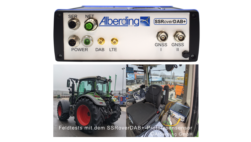
For the overall system test and the practical tests in the field, it was necessary to extend the housing to an A10 DAB+ prototype sensor, as
the DAB+ receiver module and the INS sensor could not be integrated into the existing A10 housing due to their dimensions. The fully functional
prototypes were successfully tested in the field on agricultural machinery belonging to the associated project partner BayWa AG. The tractor's
steering system used the SSR correction data transmitted via DAB+ for automated driving. The feasibility of sending precise correction data via
DAB+ was successfully demonstrated.
„The next step is to transfer the results into practice. In order to reach market maturity, future efforts must be directed towards the development
of a combined sensor solution with DAB+ modules that can be produced in smaller quantities and at a lower price,“ says Jürgen Alberding, project manager
of SSRoverDAB+ and managing director of Alberding GmbH.
You can find more project information here: